|
The Field Investigation, Risk Analysis and Risk Management of Debris Flow Torrents
主管單位:農委會水土保持局 Soil and Water Conservation Bureau
執行單位:財團法人中興工程顧問社大地工程研究中心
主持人:鄭錦桐Chin-Tung Cheng
承辦人:曹鼎志Ting-Chi Tsao
工作人員:張玉粦、林金成、李國榮、洪世勳、蔡政憲、王天佑、林彥享、溫惠鈺、趙啟宏、賴承農、許振崑、沈哲緯、邵國士、梁惠儀、謝寶珊、何幸娟、蕭震洋、辜炳寰、楊樹榮、李易叡、許志豪、施尊穎、簡榮興、鍾佩蓉、黃全謚、邱宇翔
Yu-Ling Chang, Chin-Cheng Lin, Kuo-Jung Lee, Shih-Hsun Hung, Cheng-Hsien Tsai, Tian-Yu Wang, Yen-Hsiang Lin, Hui-Yu Wen, Chi-Hung Chao, Cheng-Nong Lai, Cheng-Kun Hsu, Che-Wei Shen, Kuo-Shih Shao, Wai-Yi Leung, Pao-Shan Hsieh, Hsing-Chuan Ho, Cheng-Yang Hsiao, Bing-Huan Ku, Shu-Rong Yang, Yi-Rui Lee, Chih-Hao Hsu, Tsun-Ying Shih, Jung-Hsing Chien, Pei-Jung Chung, Chuan-Yi Huang, Yu-Hsiang Chiu
|
|
摘要
為進行災後土石流潛勢地區之調查與評估,分析土石流可能致災狀況、條件、規模與影響範圍,據以擬定疏散避難路線、避難處所及緊急救援聯絡資訊等,已成為莫拉克災後土石流災害防治之重要工作。
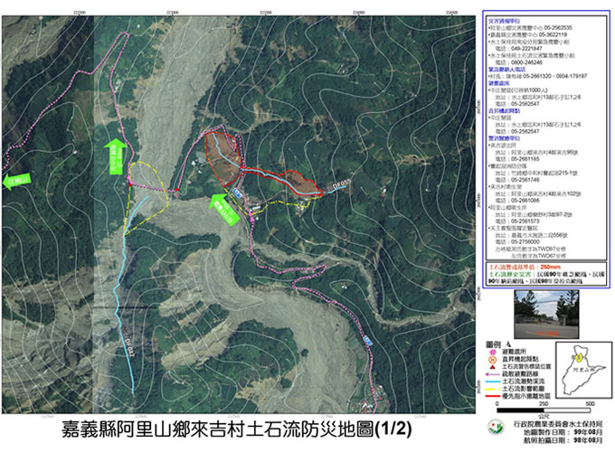
中興顧問社自2006年以來已累計完成全台1,552條土石流潛勢溪流之現地調查與防災疏散避難規劃,本計畫之第一部份「易致災因子調查」累計針對17縣市、657村里之1,552條土石流潛勢溪流進行現地調查及土石流防災地圖製作,主要工作內容包括:(1)易致災因子調查;(2)防災地圖製作。現地勘查之流程上採用5m網格之數值高程模型,搭配FLO-2D軟體模擬土石流堆積範圍,再經現勘後修正。現勘時採用3S技術,檢核模擬範圍內之保全對象住戶、避難處所及警消醫療單位相關資訊,擬定疏散避難路線,製作村里之土石流防災地圖,以有效疏散撤離此範圍內之保全對象住戶。現勘同時亦進行土石流易致災因子調查、評估現有防治設施狀況以及研擬因應對策建議等工作,所有成果以村里為單位,編彙成為村里報告,提出適當之因應對策與疏散避難規劃,提供土石流防災與救災單位規劃參用。
本計畫第二部份「風險分析」引進風險分析與管理概念,並應用遙測手段進行風險分析與土石流地質敏感區判釋,主要工作內容包括:
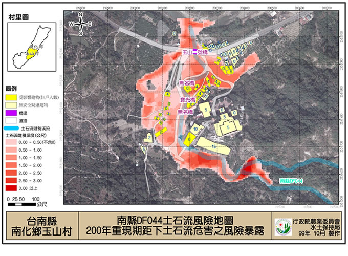
(1)累計完成重大土石流災區40村里之暴露量調查、土石流風險分析與風險地圖之製作,採用國際坡地災害風險管理理念與架構,並以莫拉克颱風資訊建構台灣本土化之易損性曲線並進行頻率分析與土石流數值模擬,進行「風險=危害潛勢×暴露量×易損性」之計算與分析,並將分析結果以圖面化之風險地圖呈現,同時亦針對台灣土石流災害提出風險管理量化評估方法與對策建議,以F-N圖統計台灣地區歷史土石流人員傷亡紀錄,並比較莫拉克颱風前後以及疏散避難措施所造成的風險管理成效;
(2)針對地方及各機關提出之新增與複勘土石流潛勢溪流進行現勘,撰寫現勘報告及製作圖資,並辦理審查會與說明會,協助水保局完成審查及公開程序,並更新相關資料庫;
(3)應用經濟部地質調查所91至95年之計畫成果所提列之8,644處土石流地質敏感區資料進行遙測判釋並與保全對象套疊,提出228條建議複勘溪流明細;
(4)整理土石流疏散避難規劃相關作業參考手冊,提出劃設溢流點、影響範圍、避難處所、避難路線之參考作業流程,以供水保局日後進行相關疏散避難作業之規劃時得有參考程序;
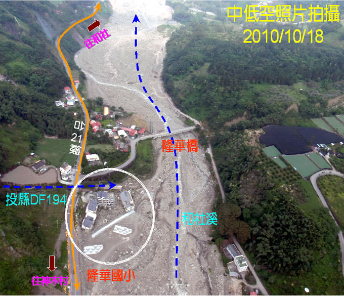
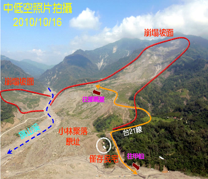
(5)針對卡玫基、辛樂克、莫拉克災區累計進行70處中低空無人載具航空拍攝。
本計畫之成果可供土石流災害疏散避難規劃及土石流風險管理之參考。
關鍵詞:土石流、3S、防災地圖、風險管理、風險分析、風險地圖
Abstract
After Typhoon Morkaot of 2009, debris flow hazard mitigation become more challenging in Taiwan. Many issues had to be reconsidered; the estimation of the magnitude and the possible inundation area of debris flows, planning the emergency evacuation routes, shelters and the emergency-response system for rescue operations.
There are two goals in the 1st part of this project, (1) investigation the current condition and suggests the renovated strategies, (2) producing the emergency evacuation map of each village for evacuation planning. Before field investigation, high resolution DEM (5m*5m) was adopted for FLO-2D input to simulate the possible inundation area of debris flow hazard. The result was the draft of priority evacuation area. Furthermore, the area was modified after field investigation. 3S (GIS, GPS, RS) techniques were not only applied to re-check the addresses of the residents in potential debris flow areas, but also to locate the shelters and emergency-response system information. Finally, all the information were combined in emergency evacuation maps and published on the internet and distributed to the local residents.
Since 2006, the 1st part of this project completed emergency evacuation maps and field investigation reports within 17 county/cities, 657 villages, 1,552 potential debris flow torrents around Taiwan. The results could provide better debris flow hazard mitigation and emergency evacuation planning.
The 2nd part of this project include (1) debris flow risk analysis and risk map production in 40 villages, (2) suggestions and evaluation method for debris flow risk management effectiveness, (3) field investigation for possible debris flow potential torrents submitted by local governments, (4) overlaying Central Geology Survey debris flow area data with possible exposures and identified 228 creeks for future investigation, (5) handbook for debris flow emergency evacuation related procedures, (6) UAV aerial photographing.
The results could be utilized in improving debris flow hazard mitigation and debris flow risk management in the future.
Keywords: Debris flow, 3S, evacuation map, risk management, risk analysis, risk map.
|